Vente de matériel aéronautique
- Atelier agréé PART 145 FAR 145
- 04 42 38 66 30 Aix-En-Provence
04 67 29 33 80 Montpellier L'Or - contact@seamavionic.com
- Une équipe à votre service
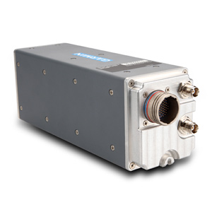
GRA 5500 Radar Altimeter
010-00946-00
15.960,00€ ttc
13.300,00€ht

Discover the All-Digital Advantage
The GRA 5500’s patent-pending digital signal processing technology can intelligently process hundreds of altitude readings every second and filter out anomalies, smooth altitude tracking and crosscheck data and system integrity. These benefits combine to provide a smooth and consistent readout of your altitude Above Ground Level (AGL). The GRA 5500 is designed to work in a multitude of environments, allowing you to go from rough terrain to tree canopies, sand to choppy water and know exactly how much room you have to maneuver. Gain added peace of mind knowing that the radar altimeter is operating normally thanks to patent-pending self-testing technology that continuously monitors incoming data and system integrity to help assure that the altitude provided is accurate, even in low-visibility conditions. In most installations, this self-testing technology eliminates the need for the pilot to interact with the GRA 5500 in any way
Interface With Your Avionics Designed to work with Garmin flight displays like the G500, G500H and G600, the GRA 5500 conveniently puts your AGL readout right in front of you. This display integration, along with its reliability and accuracy, make it an optimal solution for operators equipping for NVIS operations. The GRA 5500 also integrates with the GTS 8000 and GTX 3000 to provide a complete TCAS II system, and satisfies radar altimeter requirements for Class A TAWS systems and CAT II ILS operations. In fact, in many installations only a single GRA 5500 may be required where multiple redundant analog radar altimeters might otherwise be needed. The GRA 5500 offers a simpler installation that can further provide you with weight and cost savings by eliminating the need for long lengths of antenna cabling that are traditionally required in the installation of radar altimeters.
Interface With Your Avionics Designed to work with Garmin flight displays like the G500, G500H and G600, the GRA 5500 conveniently puts your AGL readout right in front of you. This display integration, along with its reliability and accuracy, make it an optimal solution for operators equipping for NVIS operations. The GRA 5500 also integrates with the GTS 8000 and GTX 3000 to provide a complete TCAS II system, and satisfies radar altimeter requirements for Class A TAWS systems and CAT II ILS operations. In fact, in many installations only a single GRA 5500 may be required where multiple redundant analog radar altimeters might otherwise be needed. The GRA 5500 offers a simpler installation that can further provide you with weight and cost savings by eliminating the need for long lengths of antenna cabling that are traditionally required in the installation of radar altimeters.
